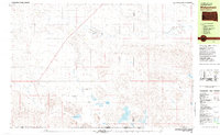
1981 Map of Wakpamani
USGS Topo · Published 1981About this map
Wakpamani sits within the high plains of the Pine Ridge Indian Reservation, where the landscape is defined by an extensive network of ephemeral and alkaline lakes. The settlement and its immediate surroundings, including the St Andrew Chapel, reflect the community's local footprint during the early 1980s. A series of water bodies like Two Lance Lake, Alkali Lake, and Feather on Head Lake dot the terrain, while drainage is largely managed by Stinking Water Creek and Spring Creek.
Find a feature on this map
21 named features on this map. Tap any name to fly to it.
Don’t see what you’re looking for? This feature index may not catch every label — zoom into the map to look around manually.
Map Details
Editions of this 1981 Wakpamani Map
2 editions found
Other maps of this area

1950 · Irwin
USGS Topo · 1:62,500

1951 · Irwin
USGS Topo · 1:62,500

1955 · Hot Springs
USGS Topo · 1:250,000

1955 · Alliance
USGS Topo · 1:250,000

1955 · Martin
USGS Topo · 1:250,000

1957 · Alliance
USGS Topo · 1:250,000

1957 · Valentine
USGS Topo · 1:250,000

1958 · Martin
USGS Topo · 1:250,000

1958 · Alliance
USGS Topo · 1:250,000

1959 · Valentine
USGS Topo · 1:250,000