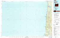
1980 Map of Waldport
USGS Topo · Published 1980About this map
Alsea Bay and the mouth of the Alsea River define the northern reaches of this coastal stretch, where the Pacific shoreline meets the steep ridges of the Coast Range. Compiled in 1980 from earlier 1950s data and updated with 1970s aerial photography, the landscape reflects a century of maritime and timber history. Small coastal communities like Waldport, Yachats, and Seal Rock are connected by the iconic Highway 101 corridor, which bridges numerous drainages such as Tenmile Creek and Big Creek.
Find a feature on this map
60 named features on this map. Tap any name to fly to it.
Don’t see what you’re looking for? This feature index may not catch every label — zoom into the map to look around manually.
Map Details
Editions of this 1980 Waldport Map
2 editions found
Other maps of this area

1918 · Mapleton
USGS Topo · 1:48,000

1919 · Earl
USGS Topo · 1:48,000

1920 · Siltcoos Lake
USGS Topo · 1:62,500

1920 · Heceta Head
USGS Topo · 1:62,500

1922 · Waldport
USGS Topo · 1:62,500

1940 · Mapleton
USGS Topo · 1:62,500

1941 · Siltcoos Lake
USGS Topo · 1:62,500

1942 · Waldport
USGS Topo · 1:62,500

1942 · Heceta Head
USGS Topo · 1:62,500

1942 · Yaquina
USGS Topo · 1:62,500