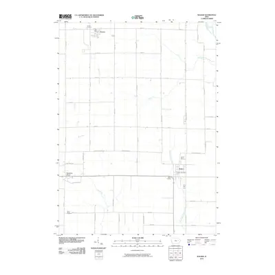
2010 Map of Walker
USGS Topo · Published 2010About this map
The Wapsipinicon River clips the northeastern corner of this landscape, a region defined by the organized grid of Linn and Buchanan counties. The settlement of Walker serves as a primary hub near the center, while Rowley anchors the northwestern reaches. This area is a patchwork of agricultural lands drained by Sand Creek and Blue Creek, with several small rural cemeteries marking the historical boundaries of local congregations. Researchers can find Saint Marys Cemetery and Sacred Heart Cemetery in the southern and central sections, respectively, highlighting the Catholic heritage of the region's settlers. The map illustrates a stable rural economy where long-standing post offices and local landmarks like Spencers Grove remain as vital points of reference amidst the steady geometry of gravel roads and section lines.
Find a feature on this map
44 named features on this map. Tap any name to fly to it.
Don’t see what you’re looking for? This feature index may not catch every label — zoom into the map to look around manually.
Map Details
Editions of this 2010 Walker Map
This is the sole edition of this map. No revisions or reprints were ever made.
Other maps of this area

1888 · Shellsburg
USGS Topo · 1:62,500

1888 · Marion
USGS Topo · 1:62,500

1889 · Marion
USGS Topo · 1:62,500

1889 · Shellsburg
USGS Topo · 1:62,500

1899 · Shellsburg
USGS Topo · 1:62,500

1903 · Winthrop
USGS Topo · 1:125,000

1959 · Dubuque
USGS Topo · 1:250,000

1961 · Dubuque
USGS Topo · 1:250,000

1962 · Dubuque
USGS Topo · 1:250,000
1968 · Lafayette
USGS Topo · 1:24,000