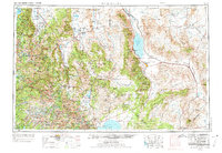
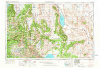
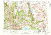
1957 Map of Walker Lake
USGS Topo · Published 1974About this map
Hawthorne Naval Ammunition Depot dominates the central landscape, situated between the Wassauk Range and the southern shores of Walker Lake. This high-desert region is defined by its dramatic Great Basin topography, where the Sierra Nevada meets the arid valleys of western Nevada. The transportation network is anchored by the Southern Pacific RR and major routes like U.S. 395 and U.S. 95, connecting military infrastructure with agricultural and mining outposts.
Find a feature on this map
143 named features on this map. Tap any name to fly to it.
Don’t see what you’re looking for? This feature index may not catch every label — zoom into the map to look around manually.
Map Details
Editions of this 1957 Walker Lake Map
4 editions found

Other maps of this area

1889 · Pyramid Peak
USGS Topo · 1:125,000

1889 · Markleeville
USGS Topo · 1:125,000

1891 · Carson
USGS Topo · 1:125,000

1891 · Markleeville
USGS Topo · 1:125,000

1891 · Truckee
USGS Topo · 1:125,000

1891 · Big Trees
USGS Topo · 1:125,000

1891 · Wabuska
USGS Topo · 1:125,000

1891 · Pyramid Peak
USGS Topo · 1:125,000

1891 · Wellington
USGS Topo · 1:125,000

1893 · Carson
USGS Topo · 1:125,000