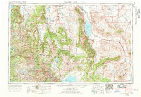
1957 Map of Walker Lake
USGS Topo · Published 1970About this map
Walker Lake anchors this mid-century landscape where high desert basins meet the towering eastern face of the Sierra Nevada. The 1969 revision captures a region defined by federal land management and military presence, notably the sprawling Hawthorne Naval Ammunition Depot and portions of Yosemite National Park. Along the Southern Pacific rail line, small hubs like Luning and Mina serve as outposts between the dry beds of Teels Marsh and Rhodes Salt Marsh. The map provides a detailed view of the transition from the alpine environment of South Lake Tahoe and the Eldorado National Forest in the west to the arid Gabbs Valley in the east. Historic agricultural centers like Yerington and Minden are shown nestled within fertile valleys, while the Walker River Indian Reservation marks the northern reaches of the primary namesake waterway.
Find a feature on this map
66 named features on this map. Tap any name to fly to it.
Don’t see what you’re looking for? This feature index may not catch every label — zoom into the map to look around manually.
Map Details
Editions of this 1957 Walker Lake Map
4 editions found

Other maps of this area

1889 · Pyramid Peak
USGS Topo · 1:125,000

1889 · Markleeville
USGS Topo · 1:125,000

1891 · Carson
USGS Topo · 1:125,000

1891 · Markleeville
USGS Topo · 1:125,000

1891 · Truckee
USGS Topo · 1:125,000

1891 · Big Trees
USGS Topo · 1:125,000

1891 · Wabuska
USGS Topo · 1:125,000

1891 · Pyramid Peak
USGS Topo · 1:125,000

1891 · Wellington
USGS Topo · 1:125,000

1893 · Carson
USGS Topo · 1:125,000