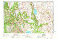
1957 Map of Walker Lake
USGS Topo · Published 1967About this map
The Walker River Indian Reservation and the desert waters of Walker Lake anchor this mid-century western survey, capturing a high-desert landscape defined by historic mining districts and military infrastructure. To the south and east, the transition from active towns like Mina and Hawthorne to the skeletal remains of the silver and gold eras is evident, with Aurora (Historic Ruins), Rawhide (Ruins), and the Bodie (Dismantled) townsite marking the boom-to-bust cycle of the previous century. The industrial footprint of the Naval Ammunition Depot near Babbitt contrasts with the remote reaches of Yosemite National Park along the western edge.
Find a feature on this map
95 named features on this map. Tap any name to fly to it.
Don’t see what you’re looking for? This feature index may not catch every label — zoom into the map to look around manually.
Map Details
Editions of this 1957 Walker Lake Map
4 editions found

Other maps of this area

1889 · Pyramid Peak
USGS Topo · 1:125,000

1889 · Markleeville
USGS Topo · 1:125,000

1891 · Carson
USGS Topo · 1:125,000

1891 · Markleeville
USGS Topo · 1:125,000

1891 · Truckee
USGS Topo · 1:125,000

1891 · Big Trees
USGS Topo · 1:125,000

1891 · Wabuska
USGS Topo · 1:125,000

1891 · Pyramid Peak
USGS Topo · 1:125,000

1891 · Wellington
USGS Topo · 1:125,000

1893 · Carson
USGS Topo · 1:125,000