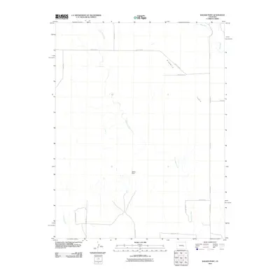
2010 Map of Walker Point
USGS Topo · Published 2010About this map
Walker Point rises as a prominent landmark within the open terrain of Lincoln County, defining the local landscape north of the various county line divisions. This 2010 survey by the U.S. Geological Survey illustrates a region dominated by a strict orthometric road grid, where County Road G and County Road F cut through the eastern expanse known as Ninemile Flats. The drainage patterns here are dictated by the seasonal flow of Dead Horse Creek, which meanders northward through the center of the quadrangle. To the northeast, the terrain is shaped by the presence of Steels Fork, while Lone Tree Creek borders the southwestern corner. The map's layout of numbered county lines, such as County Line 14 and County Line 16, reflects a highly organized rural land management system typical of the Colorado plains.
Find a feature on this map
17 named features on this map. Tap any name to fly to it.
Don’t see what you’re looking for? This feature index may not catch every label — zoom into the map to look around manually.
Map Details
Editions of this 2010 Walker Point Map
This is the sole edition of this map. No revisions or reprints were ever made.
Other maps of this area

1889 · Sanborn
USGS Topo · 1:125,000

1891 · Sanborn
USGS Topo · 1:125,000

1891 · Catlin
USGS Topo · 1:125,000

1893 · Sanborn
USGS Topo · 1:125,000

1893 · Catlin
USGS Topo · 1:125,000

1954 · Lamar
USGS Topo · 1:250,000

1958 · Lamar
USGS Topo · 1:250,000

1977 · Walker Point
USGS Topo · 1:24,000
1977 · Box Springs
USGS Topo · 1:24,000
1978 · Cockleburr Springs
USGS Topo · 1:24,000