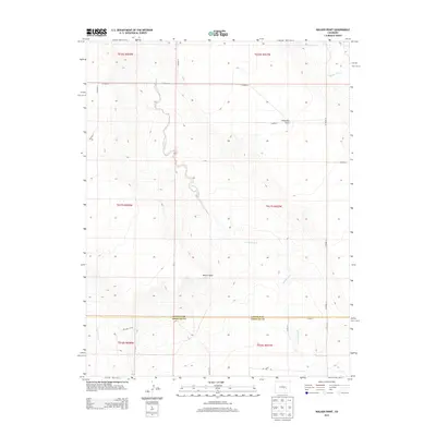
2013 Map of Walker Point
USGS Topo · Published 2013About this map
Walker Point rises as a subtle landmark in this section of the High Plains, where the border of Lincoln County and Crowley County defines the southern reach of the survey. The landscape is characterized by intermittent drainage patterns, most notably the winding path of Dead Horse Creek and the northern presence of Steels Fork. These ephemeral waterways have carved the terrain into distinct landforms like Ninemile Flats, illustrating the arid hydrology of the region. A sparse network of section-line roads, such as CO Road G and CO Road 13, provide the only infrastructure across these townships, reflecting a modern era of large-scale ranching and land management where permanent settlements are absent but the grid of the Public Land Survey System remains the primary framework for navigation and property.
Find a feature on this map
26 named features on this map. Tap any name to fly to it.
Don’t see what you’re looking for? This feature index may not catch every label — zoom into the map to look around manually.
Map Details
Editions of this 2013 Walker Point Map
This is the sole edition of this map. No revisions or reprints were ever made.
Other maps of this area

1889 · Sanborn
USGS Topo · 1:125,000

1891 · Sanborn
USGS Topo · 1:125,000

1891 · Catlin
USGS Topo · 1:125,000

1893 · Sanborn
USGS Topo · 1:125,000

1893 · Catlin
USGS Topo · 1:125,000

1954 · Lamar
USGS Topo · 1:250,000

1958 · Lamar
USGS Topo · 1:250,000

1977 · Walker Point
USGS Topo · 1:24,000
1977 · Box Springs
USGS Topo · 1:24,000
1978 · Cockleburr Springs
USGS Topo · 1:24,000