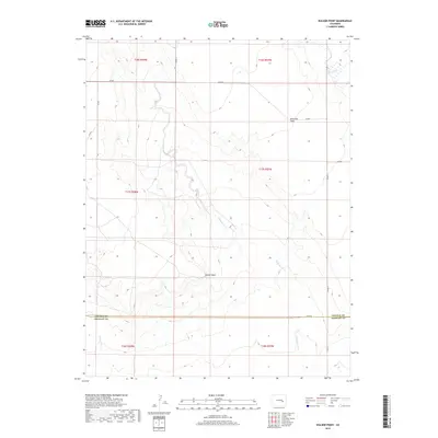
2019 Map of Walker Point
USGS Topo · Published 2019About this map
Walker Point rises as a prominent landmark in this high plains landscape along the Lincoln and Crowley County line. The terrain is defined by the ephemeral drainages of Dead Horse Cr and Lone Tree Cr, which carve through the arid expanses of Ninemile Flats. This 2019 survey documents a vast area of open country characterized by a strictly rectilinear grid of section lines and gravel routes, including Co Rd G and Co Rd 13. The absence of developed townsites on this sheet emphasizes the ranching character of the region, where water features like Steels Fork remain the primary points of orientation for land management and navigation across the township and range divisions.
Find a feature on this map
20 named features on this map. Tap any name to fly to it.
Don’t see what you’re looking for? This feature index may not catch every label — zoom into the map to look around manually.
Map Details
Editions of this 2019 Walker Point Map
This is the sole edition of this map. No revisions or reprints were ever made.
Other maps of this area

1889 · Sanborn
USGS Topo · 1:125,000

1891 · Sanborn
USGS Topo · 1:125,000

1891 · Catlin
USGS Topo · 1:125,000

1893 · Sanborn
USGS Topo · 1:125,000

1893 · Catlin
USGS Topo · 1:125,000

1954 · Lamar
USGS Topo · 1:250,000

1958 · Lamar
USGS Topo · 1:250,000

1977 · Walker Point
USGS Topo · 1:24,000
1977 · Box Springs
USGS Topo · 1:24,000
1978 · Cockleburr Springs
USGS Topo · 1:24,000