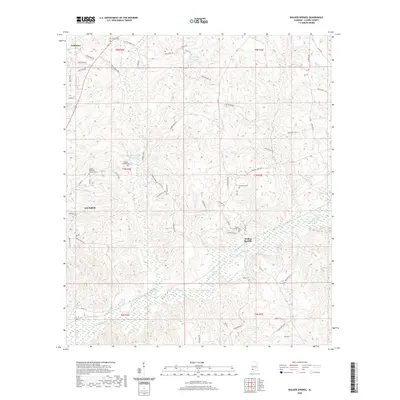
2020 Map of Walker Springs
USGS Topo · Published 2020About this map
Walker Springs and the eastern outskirts of Jackson define this landscape in central Clarke County. The area is marked by a high concentration of community landmarks, particularly country cemeteries that serve as vital records for local genealogy. From Mount Gilead Cem near the center to the isolated Hotel Cem in the south, these sites reflect the distributed settlement patterns of the Piney Woods. The terrain is deeply carved by the Bassett Creek system, which collects numerous tributaries including Simmons Creek and Rabbit Creek. In the northern reaches, the Maubila Boy Scout Lake and Lake Daddy Jim Spring indicate the importance of managed water resources and recreation. The road network, including Toddtown Rd and Rabbit Creek Rd, connects the larger town of Jackson to the smaller community of Toddtown, following the ridges between these numerous winding waterways.
Find a feature on this map
70 named features on this map. Tap any name to fly to it.
Don’t see what you’re looking for? This feature index may not catch every label — zoom into the map to look around manually.
Map Details
Editions of this 2020 Walker Springs Map
This is the sole edition of this map. No revisions or reprints were ever made.
Other maps of this area

1943 · Choctaw Bluff
USGS Topo · 1:62,500

1946 · Choctaw Bluff
USGS Topo · 1:62,500

1953 · Andalusia
USGS Topo · 1:250,000

1957 · Andalusia
USGS Topo · 1:250,000

1972 · Whatley
USGS Topo · 1:24,000

1972 · Gainestown
USGS Topo · 1:24,000

1972 · Suggsville
USGS Topo · 1:24,000

1978 · Jackson
USGS Topo · 1:24,000

1978 · Winn
USGS Topo · 1:24,000
1978 · Grove Hill
USGS Topo · 1:24,000