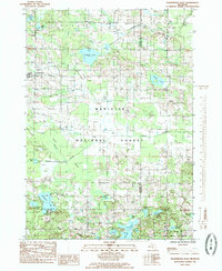
1985 Map of Walkerville East
USGS Topo · Published 1985About this map
Walkerville stands as the primary hub in this 1980s topographic study of the Michigan landscape where the northern reaches of the Manistee National Forest dominate the terrain. The area is defined by a dense network of glacial lakes and wetlands, including Gilbert Lake, Island Lake, and the southern McLaren Lake. The map reveals a transition from the structured township boundaries of Colfax and Troy into the protected timberlands of the national forest.
Find a feature on this map
34 named features on this map. Tap any name to fly to it.
Don’t see what you’re looking for? This feature index may not catch every label — zoom into the map to look around manually.
Map Details
Editions of this 1985 Walkerville East Map
This is the sole edition of this map. No revisions or reprints were ever made.
Other maps of this area

1931 · Custer SW
USGS Topo · 1:31,680

1931 · Walkerville NE
USGS Topo · 1:31,680

1931 · Walkerville SW
USGS Topo · 1:31,680

1931 · Walkerville NW
USGS Topo · 1:31,680

1931 · Custer SE
USGS Topo · 1:31,680

1931 · Walkerville SE
USGS Topo · 1:31,680

1954 · Milwaukee
USGS Topo · 1:250,000

1954 · Midland
USGS Topo · 1:250,000

1958 · Midland
USGS Topo · 1:250,000

1958 · Milwaukee
USGS Topo · 1:250,000