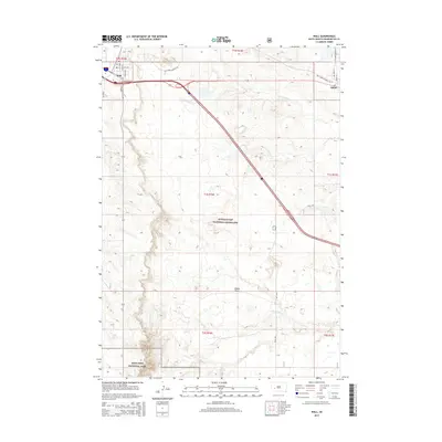
2015 Map of Wall
USGS Topo · Published 2015About this map
Wall and the neighboring settlement of Quinn anchor the northern reaches of this western South Dakota landscape, positioned along the critical interstate corridor. The map highlights the transition from the structured town grids of Wall, featuring streets like Glenn St and Dorothy St, into the expansive protected terrains of the Buffalo Gap National Grassland. To the southwest, the distinctive topography of Badlands National Park begins to emerge, where the drainages of Whitewater Cr cut through the arid plains.
Find a feature on this map
26 named features on this map. Tap any name to fly to it.
Don’t see what you’re looking for? This feature index may not catch every label — zoom into the map to look around manually.
Map Details
Editions of this 2015 Wall Map
This is the sole edition of this map. No revisions or reprints were ever made.
Other maps of this area

1953 · Rapid City
USGS Topo · 1:250,000

1954 · Wasta SE
USGS Topo · 1:24,000

1955 · Hot Springs
USGS Topo · 1:250,000

1957 · Rapid City
USGS Topo · 1:250,000

1960 · Quinn Table NE
USGS Topo · 1:24,000

1960 · Wall SE
USGS Topo · 1:24,000

1960 · Wall
USGS Topo · 1:24,000

1960 · Quinn Table SE
USGS Topo · 1:24,000
1960 · Wall SW
USGS Topo · 1:24,000
1961 · Wall NE
USGS Topo · 1:24,000