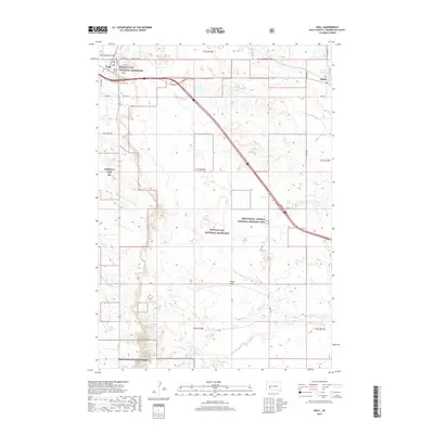
2017 Map of Wall
USGS Topo · Published 2017About this map
Wall stands as the primary hub of this Western South Dakota landscape, where the prairie of the Buffalo Gap National Grassland meets the dramatic breaks of Badlands National Park. The town layout is clearly defined, featuring local landmarks like the Wall Municipal Airport and Wall Cem. The transportation corridor is dominated by Interstate 90, which cuts a diagonal path toward the smaller settlement of Quinn to the east.
Find a feature on this map
32 named features on this map. Tap any name to fly to it.
Don’t see what you’re looking for? This feature index may not catch every label — zoom into the map to look around manually.
Map Details
Editions of this 2017 Wall Map
This is the sole edition of this map. No revisions or reprints were ever made.
Other maps of this area

1953 · Rapid City
USGS Topo · 1:250,000

1954 · Wasta SE
USGS Topo · 1:24,000

1955 · Hot Springs
USGS Topo · 1:250,000

1957 · Rapid City
USGS Topo · 1:250,000

1960 · Quinn Table NE
USGS Topo · 1:24,000

1960 · Wall SE
USGS Topo · 1:24,000

1960 · Wall
USGS Topo · 1:24,000

1960 · Quinn Table SE
USGS Topo · 1:24,000
1960 · Wall SW
USGS Topo · 1:24,000
1961 · Wall NE
USGS Topo · 1:24,000