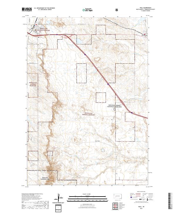
2021 Map of Wall
USGS Topo · Published 2021About this map
Wall stands at the northern edge of this West River landscape, serving as a gateway to the dramatic geology of the plains. To the south and east, the Buffalo Gap National Grassland encompasses a wide expanse of prairie punctuated by the distinct drainage systems of Cottonwood Cr and Whitewater Cr. The map documents the presence of the Minuteman Missile National Historic Site, reflecting the Cold War heritage of the South Dakota grasslands. At the southwestern corner, the boundary of Badlands National Park appears, marking the transition from the flat plains to the eroded landforms of Bloom Basin. Local landmarks like the Wall Cem and the neighboring settlement of Quinn provide specific points of reference for those tracing family ties or regional history in Pennington County.
Find a feature on this map
32 named features on this map. Tap any name to fly to it.
Don’t see what you’re looking for? This feature index may not catch every label — zoom into the map to look around manually.
Map Details
Editions of this 2021 Wall Map
This is the sole edition of this map. No revisions or reprints were ever made.
Other maps of this area

1953 · Rapid City
USGS Topo · 1:250,000

1954 · Wasta SE
USGS Topo · 1:24,000

1955 · Hot Springs
USGS Topo · 1:250,000

1957 · Rapid City
USGS Topo · 1:250,000

1960 · Quinn Table NE
USGS Topo · 1:24,000

1960 · Wall SE
USGS Topo · 1:24,000

1960 · Wall
USGS Topo · 1:24,000

1960 · Quinn Table SE
USGS Topo · 1:24,000
1960 · Wall SW
USGS Topo · 1:24,000
1961 · Wall NE
USGS Topo · 1:24,000