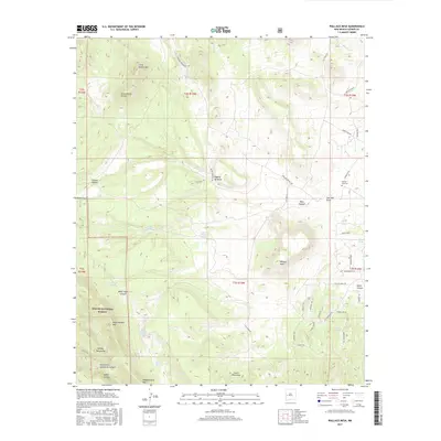
2017 Map of Wallace Mesa
USGS Topo · Published 2017About this map
Apache National Forest dominates this high-altitude landscape in western New Mexico, where the Continental Divide winds through a series of peaks and canyons. The map centers on the expansive Wallace Mesa, surrounded by landmarks like Little Alegres Mtn to the north and the Mangas Mountains to the south. This terrain is defined by its water management and transit routes, featuring isolated sources such as Sawmill Spring and Hutcherson Tank alongside significant local passes like Dutch Oven Pass and Bridger Pass. The northeastern portion of the sheet provides a point of historical interest with the Greens Gap Cem, situated near the intersection of Greens Gap Rd and Thomas IV Rd. These features, along with names like Wagontongue Mtn and White Rock Canyon, illustrate the area's history of ranching and navigation through the high desert wilderness.
Find a feature on this map
52 named features on this map. Tap any name to fly to it.
Don’t see what you’re looking for? This feature index may not catch every label — zoom into the map to look around manually.
Map Details
Editions of this 2017 Wallace Mesa Map
This is the sole edition of this map. No revisions or reprints were ever made.
Other maps of this area

1918 · Pelona
USGS Topo · 1:125,000

1954 · Clifton
USGS Topo · 1:250,000

1954 · Saint Johns
USGS Topo · 1:250,000

1957 · Clifton
USGS Topo · 1:250,000

1957 · Saint Johns
USGS Topo · 1:250,000

1958 · Clifton
USGS Topo · 1:250,000

1958 · Saint Johns
USGS Topo · 1:250,000

1962 · Clifton
USGS Topo · 1:250,000

1962 · Saint Johns
USGS Topo · 1:250,000
1981 · Cox Peak
USGS Topo · 1:24,000