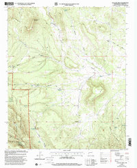
1999 Map of Wallace Mesa
USGS Topo · Published 2002About this map
The Continental Divide winds across the high desert terrain of Catron County, defining a landscape of canyons and mesas at the edge of the Gila National Forest. This late 20th-century survey shows a region where water sources dictate the geography, evidenced by isolated reliable points like Big Bear Spring, Little Bear Spring, and White Rock Spring. The high-altitude topography is anchored by Wallace Mesa and the northern reaches of the Mangas Mountains, while natural corridors like Greens Gap provide passage through the upland ridges. Settled life is marked by the presence of Collinsville and the Greens Gap Cemetery, while industrial activity is noted by a Drill Hole and the Nance Windmill. The map details a transition from the volcanic peaks of Little Alegres Mountain to the deeply carved drainage systems of Chavez Canyon and Nester Draw.
Find a feature on this map
36 named features on this map. Tap any name to fly to it.
Don’t see what you’re looking for? This feature index may not catch every label — zoom into the map to look around manually.
Map Details
Editions of this 1999 Wallace Mesa Map
This is the sole edition of this map. No revisions or reprints were ever made.
Other maps of this area

1918 · Pelona
USGS Topo · 1:125,000

1954 · Clifton
USGS Topo · 1:250,000

1954 · Saint Johns
USGS Topo · 1:250,000

1957 · Clifton
USGS Topo · 1:250,000

1957 · Saint Johns
USGS Topo · 1:250,000

1958 · Clifton
USGS Topo · 1:250,000

1958 · Saint Johns
USGS Topo · 1:250,000

1962 · Clifton
USGS Topo · 1:250,000

1962 · Saint Johns
USGS Topo · 1:250,000
1981 · Cox Peak
USGS Topo · 1:24,000