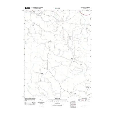
2010 Map of Wallaceton
USGS Topo · Published 2010About this map
Wallaceton serves as a central hub in this Clearfield County landscape, where several rural communities are linked by the historical Old Erie Pike. The settlement pattern follows the drainages of numerous runs, including Roaring Run, Long Run, and Laurel Run, which carve through the terrain. Evidence of the area's social history is visible in the scattered placement of landmarks like the Centre United Methodist Cemetery and Mokes Hill Cemetery, reflecting long-established family and community ties. To the south, the clusters of Gearhartville, Victor, and New Liberty show a denser concentration of development near the edge of the survey. The transport network is defined by older routes such as Old Route 322 and the Allport Cutoff, while more remote locales like Spring Valley and Pine Top sit further into the hilly outskirts. This survey captures a moment in the early 21st century when the region's coal and timber heritage is overlaid by modern transit and local aviation at Frans Airport.
Find a feature on this map
92 named features on this map. Tap any name to fly to it.
Don’t see what you’re looking for? This feature index may not catch every label — zoom into the map to look around manually.
Map Details
Editions of this 2010 Wallaceton Map
This is the sole edition of this map. No revisions or reprints were ever made.
Other maps of this area

1903 · Houtzdale
USGS Topo · 1:62,500

1905 · Houtzdale
USGS Topo · 1:62,500

1922 · Philipsburg
USGS Topo · 1:62,500

1929 · Karthaus
USGS Topo · 1:62,500

1929 · Clearfield
USGS Topo · 1:48,000

1932 · Clearfield
USGS Topo · 1:62,500

1932 · Karthaus
USGS Topo · 1:62,500

1939 · Philipsburg
USGS Topo · 1:62,500

1944 · Houtzdale
USGS Topo · 1:24,000
1944 · Glen Richey
USGS Topo · 1:24,000
Featured Places
- Bigler, Bradford Township
- Wallaceton, PA
- Pine Top, Bradford Township
- Decaturville, Decatur Township
- New Liberty, Decatur Township