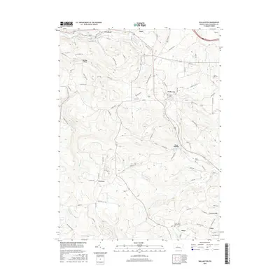
2016 Map of Wallaceton
USGS Topo · Published 2016About this map
Wallaceton and the surrounding townships of Clearfield County are defined by a network of creeks and small settlements in this mid-2010s study. The landscape is carved by numerous watercourses, including Roaring Run, Morgan Run, and Little Laurel Run, which dictate the winding paths of rural roads like Old Erie Pike and Shawville HWY. The map provides significant genealogical value through its marking of small, tucked-away burial grounds such as Goss Cem, Mokes Hill Cem, and the Centre United Methodist Cem near the southern border. Smaller localities like Newtown, Victor, and Spring Valley are clearly delineated, showing the dispersed residential pattern of the region. The inclusion of labels like Crooked Sewer RD and Cycle Club LN offers specific local landmarks that reflect the modern usage and nomenclature of these traditional Pennsylvania highlands.
Find a feature on this map
84 named features on this map. Tap any name to fly to it.
Don’t see what you’re looking for? This feature index may not catch every label — zoom into the map to look around manually.
Map Details
Editions of this 2016 Wallaceton Map
This is the sole edition of this map. No revisions or reprints were ever made.
Other maps of this area

1903 · Houtzdale
USGS Topo · 1:62,500

1905 · Houtzdale
USGS Topo · 1:62,500

1922 · Philipsburg
USGS Topo · 1:62,500

1929 · Karthaus
USGS Topo · 1:62,500

1929 · Clearfield
USGS Topo · 1:48,000

1932 · Clearfield
USGS Topo · 1:62,500

1932 · Karthaus
USGS Topo · 1:62,500

1939 · Philipsburg
USGS Topo · 1:62,500

1944 · Houtzdale
USGS Topo · 1:24,000
1944 · Glen Richey
USGS Topo · 1:24,000
Featured Places
- Bigler, Bradford Township
- Wallaceton, PA
- Pine Top, Bradford Township
- Decaturville, Decatur Township
- New Liberty, Decatur Township