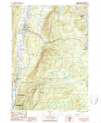
1986 Map of Wallingford
USGS Topo · Published 1987About this map
Otter Creek snakes through a deep valley on the western edge of this Vermont landscape, anchoring the principal settlement at Wallingford. During the mid-1980s, this region maintained a balance between small-scale industry, evidenced by the Marble Quarry near South Wallingford, and extensive conservation. Much of the eastern terrain is dominated by the Green Mountain National Forest, where the Appalachian Trail traverses high ridges past White Rocks and several wilderness refuges like the Little Rock Pond Shelter.
Find a feature on this map
48 named features on this map. Tap any name to fly to it.
Don’t see what you’re looking for? This feature index may not catch every label — zoom into the map to look around manually.
Map Details
Editions of this 1986 Wallingford Map
This is the sole edition of this map. No revisions or reprints were ever made.
Other maps of this area

1891 · Rutland
USGS Topo · 1:62,500

1893 · Wallingford
USGS Topo · 1:62,500

1893 · Rutland
USGS Topo · 1:62,500

1894 · Pawlet
USGS Topo · 1:62,500

1895 · Castleton
USGS Topo · 1:62,500

1897 · Pawlet
USGS Topo · 1:62,500

1897 · Castleton
USGS Topo · 1:62,500

1903 · Mettawee
USGS Topo · 1:125,000

1950 · Glens Falls
USGS Topo · 1:250,000

1955 · Wallingford
USGS Topo · 1:62,500