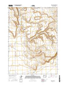
2017 Map of Walls Lake
USGS Topo · Published 2017About this map
Walls Lake Reservoir and the adjacent Walls Lake anchor this high-desert landscape in Harney County. The terrain is defined by dramatic depressions and basaltic features, most notably the circular Hole-in-the-Ground and the steep descents of Walls Lake Canyon. These natural catchments provided critical water sources for the cattle ranching operations that have long defined the region's economy. Movement through the area is dictated by the landform, with Jack Mountain Rd and Walls Lake Rd following the natural contours between the basin and the La Voy Tables. To the south, the map captures the transition into the expansive Catlow Valley, where a network of unpaved tracks like Rock Creek Ln and Clover Swail Rd connect isolated waterholes and range land. The presence of La Voy Lakes further illustrates the importance of ephemeral water in this arid interior.
Find a feature on this map
17 named features on this map. Tap any name to fly to it.
Don’t see what you’re looking for? This feature index may not catch every label — zoom into the map to look around manually.
Map Details
Editions of this 2017 Walls Lake Map
This is the sole edition of this map. No revisions or reprints were ever made.
Other maps of this area

1955 · Adel
USGS Topo · 1:250,000

1957 · Adel
USGS Topo · 1:250,000

1958 · Adel
USGS Topo · 1:250,000

1962 · Adel
USGS Topo · 1:250,000

1967 · Roaring Springs
USGS Topo · 1:24,000

1967 · Frenchglen
USGS Topo · 1:24,000
1967 · Irish Lake
USGS Topo · 1:24,000

1971 · Duhaime Flat East
USGS Topo · 1:24,000
1971 · Keg Sprs Valley East
USGS Topo · 1:24,000

1971 · Butler Hill
USGS Topo · 1:24,000