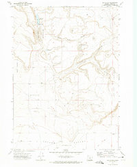
1971 Map of Walls Lake
USGS Topo · Published 1974About this map
Walls Lake Reservoir and the seasonal catchment of Walls Lake anchor this high desert landscape within Catlow Valley. Surveyed in the early 1970s, the terrain is defined by dramatic topographic sinks and depressions, most notably the aptly named Hole In The Ground and the steep escarpments of the La Voy Tables. This arid environment necessitated a specialized infrastructure of water management, evidenced by several scattered Wells and Dry Wells used to sustain livestock across the scrubland.
Find a feature on this map
20 named features on this map. Tap any name to fly to it.
Don’t see what you’re looking for? This feature index may not catch every label — zoom into the map to look around manually.
Map Details
Editions of this 1971 Walls Lake Map
This is the sole edition of this map. No revisions or reprints were ever made.
Other maps of this area

1955 · Adel
USGS Topo · 1:250,000

1957 · Adel
USGS Topo · 1:250,000

1958 · Adel
USGS Topo · 1:250,000

1962 · Adel
USGS Topo · 1:250,000

1967 · Roaring Springs
USGS Topo · 1:24,000

1967 · Frenchglen
USGS Topo · 1:24,000
1967 · Irish Lake
USGS Topo · 1:24,000

1971 · Duhaime Flat East
USGS Topo · 1:24,000
1971 · Keg Sprs Valley East
USGS Topo · 1:24,000

1971 · Butler Hill
USGS Topo · 1:24,000