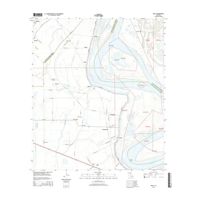
2015 Map of Walls
USGS Topo · Published 2015About this map
The Mississippi River dominates this West Baton Rouge Parish landscape, forming a massive bend that creates Profit Island and its secondary channel, Profit Island Chute. The eastern bank transitions into East Baton Rouge Parish, while the western side features a high density of small communities and landing sites. Settlements like Smithfield, Chamberlin, and Devalls follow the river's curve, connected by N River Rd. Further inland, the terrain is defined by complex water systems including Stumpy Bayou and Bayou Clause. Local history is anchored by the Chenal Cem in the north and Alford Cem near Alfords. The southern portion of the sheet shows modern infrastructure additions like the Omni Airport near Carey, illustrating how traditional river-bottom settlements have adapted over time while maintaining their proximity to the water's edge.
Find a feature on this map
78 named features on this map. Tap any name to fly to it.
Don’t see what you’re looking for? This feature index may not catch every label — zoom into the map to look around manually.
Map Details
Editions of this 2015 Walls Map
This is the sole edition of this map. No revisions or reprints were ever made.
Other maps of this area

1906 · Bayou Sara
USGS Topo · 1:125,000

1908 · Baton Rouge
USGS Topo · 1:62,500

1939 · Zachary
USGS Topo · 1:62,500

1939 · Baton Rouge
USGS Topo · 1:62,500

1940 · Grosse Tete
USGS Topo · 1:62,500

1953 · Baton Rouge West
USGS Topo · 1:24,000

1953 · Lobdell
USGS Topo · 1:24,000

1953 · New Roads
USGS Topo · 1:24,000

1954 · Zachary
USGS Topo · 1:24,000

1954 · Port Hudson
USGS Topo · 1:24,000