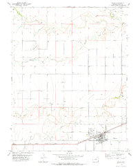
1978 Map of Walsh
USGS Topo · Published 1978About this map
Walsh serves as the focal point of this Baca County agricultural landscape, organized around the critical transportation artery of the Atchison Topeka and Santa Fe railroad. The town's infrastructure, including its storage bins, substation, and athletic field, reflects a established community supporting the surrounding high plains. Beyond the town limits, the terrain is defined by seasonal waterways like Horse Creek, Antelope Creek, and Bear Creek, which have carved notable relief into the landscape at Buffalo Point and Black Butte. This late 1970s survey illustrates a region where land use is dominated by expansive sections punctuated by numerous wells and isolated points of interest such as the Minneapolis Cem in the northeast and the small settlement of Eaton to the south. A local landing strip near the town center highlights the importance of aerial access in this corner of Colorado.
Find a feature on this map
24 named features on this map. Tap any name to fly to it.
Don’t see what you’re looking for? This feature index may not catch every label — zoom into the map to look around manually.
Map Details
Editions of this 1978 Walsh Map
This is the sole edition of this map. No revisions or reprints were ever made.
Other maps of this area

1891 · Albany
USGS Topo · 1:125,000

1892 · Vilas
USGS Topo · 1:125,000

1893 · Albany
USGS Topo · 1:125,000

1955 · La Junta
USGS Topo · 1:250,000

1958 · La Junta
USGS Topo · 1:250,000

1968 · La Junta
USGS Topo · 1:250,000

1971 · Two Buttes SE
USGS Topo · 1:24,000
1971 · Lycan
USGS Topo · 1:24,000
1971 · Two Buttes
USGS Topo · 1:24,000

1978 · Walsh SE
USGS Topo · 1:24,000