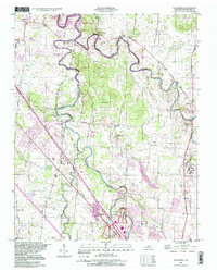
1998 Map of Walterhill
USGS Topo · Published 1999About this map
Stones River and its winding branches define this Rutherford County landscape, which includes the Stones River National Battlefield near the edge of Murfreesboro. The map captures a transition between residential expansion and established rural communities such as Old Jefferson and Walterhill. The river's path is heavily utilized for public recreation, evidenced by the Mona Recreation Area and West Fork Rec Area along the banks of J Percy Priest Lake.
Find a feature on this map
49 named features on this map. Tap any name to fly to it.
Don’t see what you’re looking for? This feature index may not catch every label — zoom into the map to look around manually.
Map Details
Editions of this 1998 Walterhill Map
This is the sole edition of this map. No revisions or reprints were ever made.
Other maps of this area

1903 · Nashville
USGS Topo · 1:125,000

1916 · Murfreesboro
USGS Topo · 1:62,500

1932 · Hermitage
USGS Topo · 1:62,500

1942 · Lebanon
USGS Topo · 1:100,000

1950 · Walterhill
USGS Topo · 1:24,000

1950 · Murfreesboro
USGS Topo · 1:24,000

1952 · La Vergne
USGS Topo · 1:24,000

1956 · Vine
USGS Topo · 1:24,000

1956 · Dillton
USGS Topo · 1:24,000

1956 · Gladeville
USGS Topo · 1:24,000