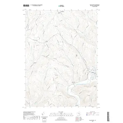
2019 Map of Walton West
USGS Topo · Published 2019About this map
The West Branch Delaware River carves a deep valley through this corner of Delaware County, anchoring the regional hub of Walton. This 2019 survey captures a landscape of steep ridges and narrow hollows, where small hamlets like Pinesville and Beerston sit along the riverbanks while others, such as Cleaver and Loomis, are tucked into the uplands. The terrain is defined by prominent peaks including Walton Mtn and Loomis Mtn, separated by intricate drainage networks like Third Brook, Pines Brook, and Windfall Brook. Local history and genealogy are preserved in the locations of the Walton Cem, Windfall Cem, and the Northfield Community Church Cem in the north near Northfield. The map reveals a persistent pattern of rural habitation where roads like Herrick Hollow Rd and Finch Hollow Rd follow the contours of the land, connecting isolated hollows to the larger river valley economy.
Find a feature on this map
98 named features on this map. Tap any name to fly to it.
Don’t see what you’re looking for? This feature index may not catch every label — zoom into the map to look around manually.
Map Details
Editions of this 2019 Walton West Map
This is the sole edition of this map. No revisions or reprints were ever made.
Other maps of this area

1915 · Oneonta
USGS Topo · 1:62,500

1915 · Unadilla
USGS Topo · 1:62,500

1918 · Unadilla
USGS Topo · 1:62,500

1918 · Oneonta
USGS Topo · 1:62,500

1923 · Walton
USGS Topo · 1:48,000

1924 · Deposit
USGS Topo · 1:62,500

1925 · Walton
USGS Topo · 1:62,500

1926 · Deposit
USGS Topo · 1:62,500

1943 · Franklin
USGS Topo · 1:24,000
1943 · Unadilla
USGS Topo · 1:24,000