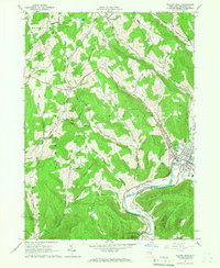
1965 Map of Walton West
USGS Topo · Published 1966About this map
The West Branch Delaware River carves a deep valley through this portion of Delaware County, centering on the village of Walton. In the mid-1960s, this landscape was defined by its transition from valley floor commerce to high-elevation forest and pasture. The village itself serves as a hub of civic life, containing the Armory, Fairgrounds, and Austin Lincoln Park. Outside the village center, small rural communities like Northfield, Loomis, and Pinesville are linked by winding roads that trace the contours of Loomis Mountain and Walton Mountain. A notable infrastructure element is the southern presence of the Cannonsville Reservoir, which along with several pipelines, reflects the region's role in large-scale water management. Local history is anchored by landmarks such as the Dryden Community Ch and the Pines Brook Ch, while the Old Railroad Grade north of Walton remains a visible relic of earlier transportation networks.
Find a feature on this map
53 named features on this map. Tap any name to fly to it.
Don’t see what you’re looking for? This feature index may not catch every label — zoom into the map to look around manually.
Map Details
Editions of this 1965 Walton West Map
2 editions found
Other maps of this area

1915 · Oneonta
USGS Topo · 1:62,500

1915 · Unadilla
USGS Topo · 1:62,500

1918 · Unadilla
USGS Topo · 1:62,500

1918 · Oneonta
USGS Topo · 1:62,500

1923 · Walton
USGS Topo · 1:48,000

1924 · Deposit
USGS Topo · 1:62,500

1925 · Walton
USGS Topo · 1:62,500

1926 · Deposit
USGS Topo · 1:62,500

1943 · Franklin
USGS Topo · 1:24,000
1943 · Unadilla
USGS Topo · 1:24,000