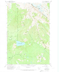
1970 Map of Walupt Lake
USGS Topo · Published 1973About this map
Walupt Lake sits at the center of this high-elevation landscape, serving as a hub for the various pack trails and seasonal encampments that defined the area in the early 1970s. The region is marked by the presence of the Walupt Lake Guard Station and several specialized sites like Horse Camp and Short Trail Camp, reflecting a managed wilderness accessible primarily by foot or animal. To the north, the terrain rises sharply toward the Goat Rocks, where permanent ice features including Conrad Glacier and Meade Glacier flank Gilbert Peak. This survey provides a precise look at the jurisdictional boundaries of the Gifford Pinchot National Forest and the Yakima Indian Reservation Boundary, documenting the network of paths like the Pacific Crest National Scenic Trail and Nannie Ridge Trail before later 20th-century shifts in forest management.
Find a feature on this map
52 named features on this map. Tap any name to fly to it.
Don’t see what you’re looking for? This feature index may not catch every label — zoom into the map to look around manually.
Map Details
Editions of this 1970 Walupt Lake Map
This is the sole edition of this map. No revisions or reprints were ever made.
Other maps of this area

1902 · Mount Aix
USGS Topo · 1:125,000

1904 · Mt Aix
USGS Topo · 1:125,000

1904 · Mount Adams
USGS Topo · 1:125,000

1907 · Mount Adams
USGS Topo · 1:125,000

1924 · Mt Rainier
USGS Topo · 1:96,000

1926 · Steamboat Mtn
USGS Topo · 1:125,000

1928 · Mt Rainier
USGS Topo · 1:125,000

1931 · Steamboat Mtn
USGS Topo · 1:125,000

1950 · Yakima
USGS Topo · 1:250,000

1958 · Yakima
USGS Topo · 1:250,000