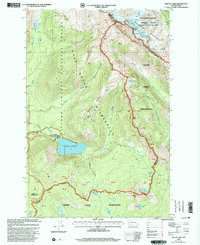
1998 Map of Walupt Lake
USGS Topo · Published 2003About this map
Walupt Lake lies at the heart of this high-elevation landscape, where the Gifford Pinchot National Forest meets the Yakama Indian Reservation. This late-twentieth-century revision illustrates the intersection of recreation and conservation within the Goat Rocks Wilderness, anchored by the massive Gilbert Peak and the surrounding Meade Glacier. The map details a complex network of glacial meltwater sources, including Goat Creek and the Cispus River, which drain the steep ridgelines of Nannie Ridge. Notable sites like Alpine Camp and Coleman Weedpatch indicate the area's use as a base for back-country travel, while the Pacific Crest National Scenic Trail winds along the eastern boundary. The presence of the Indian Boundary serves as a critical historical marker, separating the protected wilderness from the reservation lands to the east.
Find a feature on this map
60 named features on this map. Tap any name to fly to it.
Don’t see what you’re looking for? This feature index may not catch every label — zoom into the map to look around manually.
Map Details
Editions of this 1998 Walupt Lake Map
This is the sole edition of this map. No revisions or reprints were ever made.
Other maps of this area

1902 · Mount Aix
USGS Topo · 1:125,000

1904 · Mt Aix
USGS Topo · 1:125,000

1904 · Mount Adams
USGS Topo · 1:125,000

1907 · Mount Adams
USGS Topo · 1:125,000

1924 · Mt Rainier
USGS Topo · 1:96,000

1926 · Steamboat Mtn
USGS Topo · 1:125,000

1928 · Mt Rainier
USGS Topo · 1:125,000

1931 · Steamboat Mtn
USGS Topo · 1:125,000

1950 · Yakima
USGS Topo · 1:250,000

1958 · Yakima
USGS Topo · 1:250,000