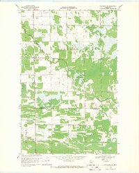
1968 Map of Wannaska SW
USGS Topo · Published 1971About this map
Golden Valley and Linsell define this late-1960s landscape, where the flat, marshy terrain of northwestern Minnesota is punctuated by isolated farmsteads and rural landmarks. The drainage of the South Fork Roseau River and the Moose River dominates the hydrology, reflecting the complex water management required in this low-lying region. Small centers of community life are preserved here, notably Casperson with its Townhall and the settlement of Torfin to the northwest. For those tracing family ties to the area, the map records Bethlehem Ch and the Golden Valley Cem, providing specific locations for local genealogy. This survey also shows the northern reaches of the Red Lake Indian Reservation, illustrating the intersection of tribal lands and county boundaries between Roseau and Marshall Counties.
Find a feature on this map
13 named features on this map. Tap any name to fly to it.
Don’t see what you’re looking for? This feature index may not catch every label — zoom into the map to look around manually.
Map Details
Editions of this 1968 Wannaska SW Map
2 editions found
Other maps of this area

1918 · Rollis
USGS Topo · 1:62,500

1918 · Pencer
USGS Topo · 1:62,500

1918 · Garland
USGS Topo · 1:62,500

1919 · Liner
USGS Topo · 1:62,500

1943 · Rollis
USGS Topo · 1:62,500

1954 · Roseau
USGS Topo · 1:250,000

1957 · Roseau
USGS Topo · 1:250,000

1958 · Roseau
USGS Topo · 1:250,000

1962 · Gatzke
USGS Topo · 1:24,000
1967 · Thief Lake NE
USGS Topo · 1:24,000