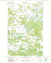
1968 Map of Wannaska SW
USGS Topo · Published 1984About this map
The South Fork Roseau River meanders across this northern Minnesota landscape, crossing the boundary between Golden Valley and Linsell as it flows through the Red Lake Indian Reservation. This 1960s survey, updated in the early 1980s, reveals a quiet agricultural and wooded expanse where small community centers like Torfin and Casperson anchor the rural sections. A Townhall and Bethlehem Ch serve as local landmarks alongside the Golden Valley Cem. The map illustrates the hydrological complexity of the region, where the Moose River moves through the southern reaches, and numerous Gravel Pits indicate local industry. The township lines for Palmville and the Roseau and Marshall County line provide essential reference points for genealogists and local historians tracking land ownership in these townships.
Find a feature on this map
14 named features on this map. Tap any name to fly to it.
Don’t see what you’re looking for? This feature index may not catch every label — zoom into the map to look around manually.
Map Details
Editions of this 1968 Wannaska SW Map
2 editions found
Other maps of this area

1918 · Rollis
USGS Topo · 1:62,500

1918 · Pencer
USGS Topo · 1:62,500

1918 · Garland
USGS Topo · 1:62,500

1919 · Liner
USGS Topo · 1:62,500

1943 · Rollis
USGS Topo · 1:62,500

1954 · Roseau
USGS Topo · 1:250,000

1957 · Roseau
USGS Topo · 1:250,000

1958 · Roseau
USGS Topo · 1:250,000

1962 · Gatzke
USGS Topo · 1:24,000
1967 · Thief Lake NE
USGS Topo · 1:24,000