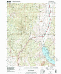
1997 Map of Wanship
USGS Topo · Published 2001About this map
Wanship and Hoytsville anchor this valley corridor where the Weber River and Silver Creek converge. The landscape is dominated by the Rockport Lake reservoir, created by the Wanship Dam, which submerged portions of the valley floor now managed as Rockport State Park. The transportation network is a central theme, with the Union Pacific Railroad winding alongside the river and Interstate 80 tracing the path of the old Silver Creek canyon. This late-century survey captures the region's balance between infrastructure and recreation, showing boat ramps and a Gaging Station near the water, while the surrounding high ground like Lewis Peak is cut by numerous family-named drainages including Bradbury Canyon and Alexander Canyon. Small Cem sites near the lake shore offer touchpoints for genealogists interested in the early settlers of this Summit County junction.
Find a feature on this map
37 named features on this map. Tap any name to fly to it.
Don’t see what you’re looking for? This feature index may not catch every label — zoom into the map to look around manually.
Map Details
Editions of this 1997 Wanship Map
This is the sole edition of this map. No revisions or reprints were ever made.
Other maps of this area

1885 · Salt Lake
USGS Topo · 1:250,000

1900 · Coalville
USGS Topo · 1:125,000

1903 · Coalville
USGS Topo · 1:125,000

1925 · Ft. Douglas
USGS Topo · 1:125,000

1928 · Ft. Douglas
USGS Topo · 1:125,000

1954 · Salt Lake City
USGS Topo · 1:250,000

1955 · Park City East
USGS Topo · 1:24,000

1955 · Park City West
USGS Topo · 1:24,000

1958 · Salt Lake City
USGS Topo · 1:250,000

1960 · Salt Lake City
USGS Topo · 1:250,000