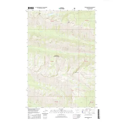
2017 Map of Ward Mountain
USGS Topo · Published 2017About this map
Ward Mountain and Canyon Peak dominate this high-elevation landscape within the Bitterroot National Forest. The 2017 terrain is defined by a series of steep drainages, including Roaring Lion Cr and Sawtooth Cr, which fall away from the Bitterroot Divide. High alpine lakes such as Wyant Lake, Canyon Lake, and E Lake are tucked into glacial cirques below the summits, with Canyon Falls marking a significant drop in the upper reaches of Canyon Cr. This map shows a primitive wilderness environment largely untouched by development, save for the access provided by Lost Horse Rd in the southern portion of the quadrangle. The network of creeks, from Camas Cr to Gold Cr, illustrates the complex watershed feeding the valley floor to the east. For the researcher, the map preserves the exact boundaries of numerous forest land sections and public land survey markers.
Find a feature on this map
37 named features on this map. Tap any name to fly to it.
Don’t see what you’re looking for? This feature index may not catch every label — zoom into the map to look around manually.
Map Details
Editions of this 2017 Ward Mountain Map
This is the sole edition of this map. No revisions or reprints were ever made.
Other maps of this area

1901 · Hamilton
USGS Topo · 1:125,000

1956 · Hamilton
USGS Topo · 1:250,000

1959 · Hamilton
USGS Topo · 1:250,000

1960 · Hamilton
USGS Topo · 1:250,000

1964 · Hamilton
USGS Topo · 1:250,000

1964 · Hamilton South
USGS Topo · 1:24,000

1964 · Tenmile Lake
USGS Topo · 1:24,000

1964 · Darby
USGS Topo · 1:24,000

1964 · Ward Mountain
USGS Topo · 1:24,000
1964 · El Capitan
USGS Topo · 1:24,000