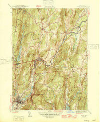
1946 Map of Ware
USGS Topo · Published 1946About this map
The Ware River carves a deep industrial and transit corridor through Worcester County, anchoring a string of mill settlements including Gilbertville, Wheelwright, and Furnace. Surveyed just before the mid-century, this map captures the tight relationship between the river's path and the rail infrastructure of the Boston and Albany and Boston and Maine lines. While these valley towns show concentrated development, the surrounding uplands of Hardwick and New Braintree remain defined by dispersed farmsteads and rural landmarks like Mandell Hill and School No 2. A notable engineering feature is the Quabbin Aqueduct passing beneath the terrain in the northwest, part of the massive regional water system. From the southern expanse of Wickaboag Pond to the heights of Dougal Mountain, the map documents a landscape of high-elevation drumlins and narrow, active valleys.
Find a feature on this map
35 named features on this map. Tap any name to fly to it.
Don’t see what you’re looking for? This feature index may not catch every label — zoom into the map to look around manually.
Map Details
Editions of this 1946 Ware Map
2 editions found
Other maps of this area

1887 · Brookfield
USGS Topo · 1:62,500

1887 · Palmer
USGS Topo · 1:62,500

1887 · Belchertown
USGS Topo · 1:62,500

1887 · Barre
USGS Topo · 1:62,500

1889 · Palmer
USGS Topo · 1:62,500

1889 · Barre
USGS Topo · 1:62,500

1890 · Belchertown
USGS Topo · 1:62,500

1890 · Brookfield
USGS Topo · 1:62,500

1893 · Palmer
USGS Topo · 1:62,500

1893 · Belchertown
USGS Topo · 1:62,500