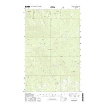
2017 Map of Warland Peak
USGS Topo · Published 2017About this map
Kootenai National Forest dominates this mountainous landscape in Lincoln County, characterized by high ridges and a dense network of watercourses. The high ground is anchored by the Warland Peak Lookout atop Warland Peak, a vital vantage point overlooking the extensive Warland Ridge to the north and the Canyon Divide to the west. This 2017 survey details the complex drainage patterns of the area, where headwaters like Summit Spring feed into systems such as Cripple Horse Cr and Threemile Cr. Further south, the terrain rises toward Weigel Mtn and the prominent Wolf Point, with the land carved by Weigel Creek. The map provides a clear picture of the Forest Service road network that provides access through these drainages, illustrating the modern management and recreational infrastructure of this portion of northwest Montana.
Find a feature on this map
22 named features on this map. Tap any name to fly to it.
Don’t see what you’re looking for? This feature index may not catch every label — zoom into the map to look around manually.
Map Details
Editions of this 2017 Warland Peak Map
This is the sole edition of this map. No revisions or reprints were ever made.
Other maps of this area

1913 · Stryker
USGS Topo · 1:125,000

1916 · Stryker
USGS Topo · 1:125,000

1920 · Jennings
USGS Topo · 1:125,000

1935 · Thompson Lakes
USGS Topo · 1:96,000

1942 · Thompson Lakes
USGS Topo · 1:125,000

1957 · Kalispell
USGS Topo · 1:250,000

1960 · Kalispell
USGS Topo · 1:250,000

1961 · Kalispell
USGS Topo · 1:250,000

1963 · Wolf Prairie
USGS Topo · 1:24,000

1963 · Davis Mountain
USGS Topo · 1:24,000