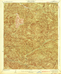
1936 Map of Warm Spring
USGS Topo · Published 1936About this map
Angeles National Forest defines the interior landscape of northern Los Angeles County in the mid-1930s, dominated by the tectonic and topographic features of the Sierra Pelona and surrounding ranges. The northern margin is marked by the San Andreas Rift Zone, where the Elizabeth Lake Pine Canyon Rd follows the distinct geological depression. Deep within the mountains, a Lookout on Sawmill Mountain and the Sawmill Firebreak indicate early 20th-century forest management and fire suppression efforts in this high-elevation terrain. Drainage patterns are well-defined by prominent gorges such as Elizabeth Lake Canyon, Warm Spring Canyon, and Ruby Canyon. This 1931 survey illustrates a period before significant modern development, focusing on the infrastructure of the forest service and the natural watercourses that feed the basins below, including Rattlesnake Canyon and Fish Canyon.
Find a feature on this map
22 named features on this map. Tap any name to fly to it.
Don’t see what you’re looking for? This feature index may not catch every label — zoom into the map to look around manually.
Map Details
Editions of this 1936 Warm Spring Map
3 editions found
Other maps of this area

1903 · Tejon
USGS Topo · 1:125,000

1915 · Elizabeth Lake
USGS Topo · 1:125,000

1917 · Elizabeth Lake
USGS Topo · 1:125,000

1931 · Red Mountain
USGS Topo · 1:24,000

1931 · Warm Spring
USGS Topo · 1:24,000

1931 · Redrock Mtn
USGS Topo · 1:24,000
1932 · La Brun
USGS Topo · 1:24,000

1932 · Hughes Lake
USGS Topo · 1:24,000

1932 · Fairmont
USGS Topo · 1:24,000

1932 · Neenach
USGS Topo · 1:24,000