
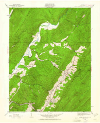
1930 Map of Warm Springs Run
USGS Topo · Published 1930About this map
Jackson River carves a path through the steep terrain of Bath County, anchoring a landscape where narrow valleys dictate the pattern of human settlement. This 1930 advance sheet, surveyed by Albert Pike and his team, shows the rural communities of Thomastown and Mitchelltown tucked into the lower elevations between massive ridges. The presence of Thomastown Sch, Mt Home Ch, and Chalybeate Run Ch reflects the social infrastructure of these mountain enclaves during the early twentieth century. Extensive drainage systems including Cowardin Run, Jerry Run, and Warm Springs Run create the complex topography that defines the region, while landmarks like State Mountain and Mare Mountain rise sharply above the river. The map provides an intricate look at the roadway and trail network connecting the high ridges of Mountain Grove to the thermal waters of Hot Springs.
Find a feature on this map
24 named features on this map. Tap any name to fly to it.
Don’t see what you’re looking for? This feature index may not catch every label — zoom into the map to look around manually.
Map Details
Editions of this 1930 Warm Springs Run Map
2 editions found
Other maps of this area

1894 · Natural Bridge
USGS Topo · 1:125,000

1901 · Monterey
USGS Topo · 1:125,000

1923 · Warm Springs
USGS Topo · 1:48,000

1926 · Warm Springs
USGS Topo · 1:62,500

1929 · Falling Spring
USGS Topo · 1:24,000

1930 · Mountain Grove
USGS Topo · 1:24,000

1931 · Healing Springs
USGS Topo · 1:24,000

1932 · Falling Spring
USGS Topo · 1:31,680

1933 · Mountain Grove
USGS Topo · 1:31,680

1933 · Warm Springs Run
USGS Topo · 1:31,680