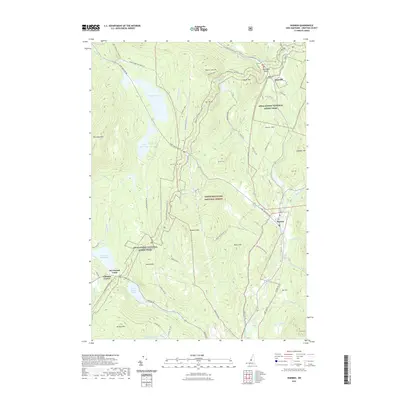
2021 Map of Warren
USGS Topo · Published 2021About this map
The White Mountain National Forest dominates this landscape, where the Appalachian National Scenic Trail winds through complex topography from Oliverian Notch past Mt Mist and Sentinel Mtn. The settlement of Warren serves as a local hub near the confluence of Patch Brook and the Baker River, while Glencliff sits to the north along the corridor of the Oliverian Brook. Historic land use is evidenced by Ore Hill, which names both a significant peak and a nearby road, hinting at the region's mining past. Notable water bodies including Lake Tarleton, Lake Armington, and the more secluded Wachipauka Pond are connected by a network of snowmobile trails like the Charlestown Rd Snomo Trl and Meader Pond Snomo Trl. Numerous family-named landmarks such as Atwell Hill and Nichols Hill provide valuable geographic markers for genealogists.
Find a feature on this map
68 named features on this map. Tap any name to fly to it.
Don’t see what you’re looking for? This feature index may not catch every label — zoom into the map to look around manually.
Map Details
Editions of this 2021 Warren Map
This is the sole edition of this map. No revisions or reprints were ever made.
Other maps of this area

1928 · Rumney
USGS Topo · 1:62,500

1929 · Moosilauke
USGS Topo · 1:62,500

1931 · Mt. Cube
USGS Topo · 1:62,500

1931 · Woodsville
USGS Topo · 1:48,000

1932 · Rumney
USGS Topo · 1:62,500

1932 · Moosilauke
USGS Topo · 1:62,500

1933 · Mt. Cube
USGS Topo · 1:62,500

1935 · Woodsville
USGS Topo · 1:62,500

1941 · Woodsville
USGS Topo · 1:62,500

1949 · Portland
USGS Topo · 1:250,000