1971 Map of Warren Lake
USGS Topo · Published 1974About this map
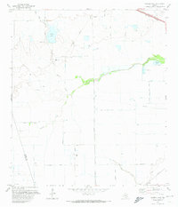
Warren Lake and the adjacent Warren Ranch define the northwest corner of this Harris County landscape as it appeared in the early 1970s. The terrain is characterized by the meandering path of Cypress Creek, which flows eastward toward a Fish Hatchery and Mallard Lake. This map captures a rural Texas transition, where vast agricultural holdings are segmented by early infrastructure like the Southern Pacific rail line and numerous petroleum pipelines.
Find a feature on this map
26 named features on this map. Tap any name to fly to it.
Don’t see what you’re looking for? This feature index may not catch every label — zoom into the map to look around manually.
Map Details
Editions of this 1971 Warren Lake Map
2 editions found
Historical Maps of Houston Through Time
93 maps found

1915 Addicks
Harris County, TX

1915 Alief
Harris County, TX

1915 Cypress
Harris County, TX

1915 Deepwater
Harris County, TX

1915 Hillendahl
Harris County, TX

1915 Houston Heights
Harris County, TX

1915 Park Place
Harris County, TX

1916 Burnett Bay
Harris County, TX

1916 Cedar Bayou
Harris County, TX

1916 Fauna
Harris County, TX

1916 Genoa
Harris County, TX

1916 Harmaston
Harris County, TX

1916 Hockley
Harris County, TX

1916 Huffman
Harris County, TX

1916 Louetta
Harris County, TX

1916 Moonshine Hill
Harris County, TX

1916 Rose Hill
Harris County, TX

1916 Satsuma
Harris County, TX

1916 Settegast
Harris County, TX

1916 Swanson
Harris County, TX

1918 Addicks
Harris County, TX

1918 Cypress
Harris County, TX

1918 Hillendahl
Harris County, TX

1919 Cedar Bayou
Harris County, TX

1919 Deepwater
Harris County, TX

1919 Swanson
Harris County, TX

1920 Burnett Bay
Harris County, TX

1920 Fauna
Harris County, TX

1920 Genoa
Harris County, TX

1920 Harmaston
Harris County, TX

1920 Hockley
Harris County, TX

1920 Huffman
Harris County, TX

1920 Louetta
Harris County, TX

1920 Moonshine Hill
Harris County, TX

1920 Rose Hill
Harris County, TX

1920 Satsuma
Harris County, TX

1922 Houston Heights
Harris County, TX

1922 Park Place
Harris County, TX

1922 Settegast
Harris County, TX

1932 Fauna
Harris County, TX

1932 Genoa
Harris County, TX

1943 Cedar Bayou
Harris County, TX

1944 Burnett Bay
Harris County, TX

1944 Harmaston
Harris County, TX

1946 Houston Heights
Harris County, TX

1946 Settegast
Harris County, TX

1954 Harmaston
Harris County, TX

1955 Addicks
Harris County, TX

1955 Houston Heights
Harris County, TX

1955 Park Place
Harris County, TX

1955 Settegast
Harris County, TX

1960 Huffman
Harris County, TX

1961 Moonshine Hill
Harris County, TX

1962 Hockley
Harris County, TX

1962 Rose Hill
Harris County, TX

1967 Harmaston
Harris County, TX

1967 Houston Heights
Harris County, TX

1967 Park Place
Harris County, TX

1967 Settegast
Harris County, TX

1970 Addicks
Harris County, TX

1970 Alief
Harris County, TX

1970 Cypress
Harris County, TX

1970 Satsuma
Harris County, TX

1971 Warren Lake
Harris County, TX

1982 Alief
Harris County, TX

1982 Freindswood
Harris County, TX

1982 Harmaston
Harris County, TX

1982 Houston Heights
Harris County, TX

1982 Park Place
Harris County, TX

1982 Satsuma
Harris County, TX

1982 Settegast
Harris County, TX

1995 Addicks
Harris County, TX

1995 Alief
Harris County, TX

1995 Cypress
Harris County, TX

1995 Harmaston
Harris County, TX

1995 Houston Heights
Harris County, TX

1995 Moonshine Hill
Harris County, TX

1995 Park Place
Harris County, TX

1995 Satsuma
Harris County, TX

1995 Settegast
Harris County, TX

2022 Addicks
Harris County, TX

2022 Alief
Harris County, TX

2022 Cypress
Harris County, TX

2022 Harmaston
Harris County, TX

2022 Hockley
Harris County, TX

2022 Houston Heights
Harris County, TX

2022 Huffman
Harris County, TX

2022 Moonshine Hill
Harris County, TX

2022 Park Place
Harris County, TX

2022 Rose Hill
Harris County, TX

2022 Satsuma
Harris County, TX

2022 Settegast
Harris County, TX

2022 Warren Lake
Harris County, TX