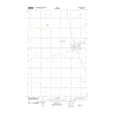
2010 Map of Warren
USGS Topo · Published 2010About this map
Warren serves as the focal point of this Marshall County survey, situated along the winding course of the Snake River. The town's grid is established west of the river, while local history is anchored at the Greenwood Cemetery and the adjacent Catholic Cemetery on the eastern bank. The landscape around the settlement is defined by the flat, productive reaches of the Red River Valley, where the Snake River meanders through agricultural fields. To the north, the Melgard Coulee cuts into the terrain, illustrating the drainage patterns essential to this region's farming heritage. Infrastructure on the periphery includes the Roan Airport to the southeast and the Warren Riverside Golf Course, highlighting the town's development into a regional center by the early 21st century. The map provides a precise layout of the county highway system, such as County Hwy-230 and County Hwy-20, which structure the rural landscape.
Find a feature on this map
20 named features on this map. Tap any name to fly to it.
Don’t see what you’re looking for? This feature index may not catch every label — zoom into the map to look around manually.
Map Details
Editions of this 2010 Warren Map
This is the sole edition of this map. No revisions or reprints were ever made.
Other maps of this area

1918 · Angus
USGS Topo · 1:62,500

1918 · Argyle
USGS Topo · 1:62,500

1918 · Warren
USGS Topo · 1:62,500

1952 · Thief River Falls
USGS Topo · 1:250,000

1954 · Stephen
USGS Topo · 1:62,500

1955 · Warren
USGS Topo · 1:62,500

1956 · Thief River Falls
USGS Topo · 1:250,000

1956 · Florian
USGS Topo · 1:62,500

1957 · Thief River Falls
USGS Topo · 1:250,000
1961 · Angus
USGS Topo · 1:24,000