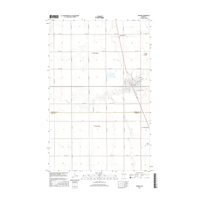
2016 Map of Warren
USGS Topo · Published 2016About this map
Warren serves as the primary hub of this Red River Valley landscape, situated where the meandering Snake River cuts through the flat agricultural plains of northwestern Minnesota. The town's grid is well-defined, featuring streets such as N Minnesota St and S Main St that radiate from its center. On the northeastern edge of town, the Greenwood Cem and Catholic Cem provide significant points of interest for genealogists tracing family roots in Marshall County. The surrounding terrain is characterized by a precise network of section-line roads like 250th St NW and drainage features such as Melgard Coulee, illustrating the intensive land management typical of this productive farming region. To the southeast, Roan Airport marks a modern transport link in this otherwise rural setting, which straddles the border between Marshall and Polk Counties.
Find a feature on this map
43 named features on this map. Tap any name to fly to it.
Don’t see what you’re looking for? This feature index may not catch every label — zoom into the map to look around manually.
Map Details
Editions of this 2016 Warren Map
This is the sole edition of this map. No revisions or reprints were ever made.
Other maps of this area

1918 · Angus
USGS Topo · 1:62,500

1918 · Argyle
USGS Topo · 1:62,500

1918 · Warren
USGS Topo · 1:62,500

1952 · Thief River Falls
USGS Topo · 1:250,000

1954 · Stephen
USGS Topo · 1:62,500

1955 · Warren
USGS Topo · 1:62,500

1956 · Thief River Falls
USGS Topo · 1:250,000

1956 · Florian
USGS Topo · 1:62,500

1957 · Thief River Falls
USGS Topo · 1:250,000
1961 · Angus
USGS Topo · 1:24,000