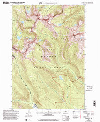
1997 Map of Warren Peak
USGS Topo · Published 2002About this map
Warren Peak stands as a central monument along the Continental Divide, marking the high-altitude boundary where the Deerlodge National Forest meets the Beaverhead National Forest. This late-twentieth-century survey documents a high-country landscape defined by the sharp transitions of the Anaconda Pintler Wilderness. Glacial activity is evident in the numerous alpine basins like Glover Basin and Maloney Basin, as well as a cluster of high-elevation water bodies including Edith Lake, Johnson Lake, and Rainbow Lake.
Find a feature on this map
39 named features on this map. Tap any name to fly to it.
Don’t see what you’re looking for? This feature index may not catch every label — zoom into the map to look around manually.
Map Details
Editions of this 1997 Warren Peak Map
This is the sole edition of this map. No revisions or reprints were ever made.
Other maps of this area

1908 · Philipsburg
USGS Topo · 1:125,000

1909 · Sapphire
USGS Topo · 1:125,000

1947 · Butte
USGS Topo · 1:250,000

1955 · Dillon
USGS Topo · 1:250,000

1957 · Dillon
USGS Topo · 1:250,000

1958 · Butte
USGS Topo · 1:250,000

1958 · Dillon
USGS Topo · 1:250,000

1960 · Butte
USGS Topo · 1:250,000

1962 · Butte
USGS Topo · 1:250,000

1962 · Dillon
USGS Topo · 1:250,000