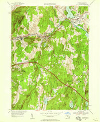
1954 Map of Warren
USGS Topo · Published 1958About this map
The Quaboag River valley serves as the primary corridor for transportation and industry through the towns of Warren and West Warren during the mid-1950s. This survey, revised just as the Massachusetts Turnpike was carved through the landscape, shows the transition of central Massachusetts from a rail-dependent manufacturing district to an automobile-oriented region. The industrial character of the valley is balanced by the dense network of summits like Marks Mountain and Colonels Mtn, while the village of West Brookfield anchors the northeastern corner near the shores of Wickaboag Pond. Local landmarks such as the St Marys Cem and the Sacred Heart church provide critical touchpoints for genealogists tracking family history in these tight-knit riverside communities. The southern reaches are more sparsely settled, featuring smaller hamlets like Little Rest and numerous water bodies including Sherman Pond and Little Alum Pond.
Find a feature on this map
41 named features on this map. Tap any name to fly to it.
Don’t see what you’re looking for? This feature index may not catch every label — zoom into the map to look around manually.
Map Details
Editions of this 1954 Warren Map
3 editions found
Other maps of this area

1887 · Brookfield
USGS Topo · 1:62,500

1887 · Palmer
USGS Topo · 1:62,500

1887 · Belchertown
USGS Topo · 1:62,500

1887 · Barre
USGS Topo · 1:62,500

1889 · Palmer
USGS Topo · 1:62,500

1889 · Barre
USGS Topo · 1:62,500

1890 · Belchertown
USGS Topo · 1:62,500

1890 · Brookfield
USGS Topo · 1:62,500

1893 · Palmer
USGS Topo · 1:62,500

1893 · Belchertown
USGS Topo · 1:62,500