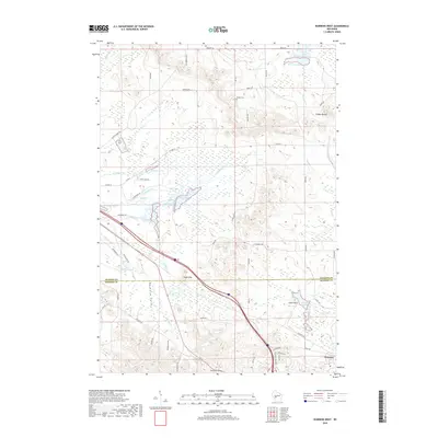
2018 Map of Warrens West
USGS Topo · Published 2018About this map
The village of Warrens serves as the focal point for this survey along the border of Jackson and Monroe Counties. The landscape is defined by the cranberry-producing character of Central Wisconsin, evidenced by numerous water bodies including Robinson Pond, Wazeda Lake, and the complex network of Ketchum Cr and Rudd Cr. The terrain transitions from the low-lying Paradise Valley to prominent landmarks like Knapp Mound and the Rudd Hills. For those tracing local heritage, the map identifies residential developments such as the Neimi Addition and quiet landmarks like the Knapp Cem. The area is geographically diverse, featuring significant rock formations like Castle Rock and the drainage of the E Fork Lemonweir River, providing a clear look at the region’s hydraulic and topographical features during the late 2010s.
Find a feature on this map
62 named features on this map. Tap any name to fly to it.
Don’t see what you’re looking for? This feature index may not catch every label — zoom into the map to look around manually.
Map Details
Editions of this 2018 Warrens West Map
This is the sole edition of this map. No revisions or reprints were ever made.
Other maps of this area

1947 · Millston
USGS Topo · 1:62,500

1949 · Millston
USGS Topo · 1:62,500

1953 · Eau Claire
USGS Topo · 1:250,000

1957 · City Point
USGS Topo · 1:48,000

1958 · Eau Claire
USGS Topo · 1:250,000

1958 · Hatfield
USGS Topo · 1:48,000

1958 · Wyeville
USGS Topo · 1:48,000

1964 · Eau Claire
USGS Topo · 1:250,000
1970 · Hatfield SW
USGS Topo · 1:24,000
1970 · Wyeville
USGS Topo · 1:24,000