
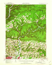
1953 Map of Warrensville
USGS Topo · Published 1956About this map
Lycoming Creek and the Pennsylvania railroad carve a narrow industrial and transportation corridor through the western mountains of this mid-century survey. The landscape transitions from the high, plateau-like summits of Potash Mountain and Sharp Top in the north to the more densely settled valley of Loyalsock Creek further south. Notable clusters of rural community life appear at Barbours, Kellyburg, and Proctor, where small settlements are centered around local churches like the Church of the Assumption and social hubs like the State Game Farm.
Find a feature on this map
128 named features on this map. Tap any name to fly to it.
Don’t see what you’re looking for? This feature index may not catch every label — zoom into the map to look around manually.
Map Details
Editions of this 1953 Warrensville Map
2 editions found
Other maps of this area

1921 · Williamsport
USGS Topo · 1:48,000

1921 · Trout Run
USGS Topo · 1:62,500

1923 · Trout Run
USGS Topo · 1:62,500

1923 · Williamsport
USGS Topo · 1:62,500

1924 · Milton
USGS Topo · 1:62,500

1925 · Blossburg
USGS Topo · 1:62,500

1927 · Eagles Mere
USGS Topo · 1:48,000

1927 · Blossburg
USGS Topo · 1:62,500

1930 · Warrensville
USGS Topo · 1:62,500

1932 · Eagle Mere
USGS Topo · 1:62,500
Featured Places
- Williamsport, PA
- Faxon, Loyalsock Township
- Hillsgrove Township, PA
- Butternut Grove, Gamble Township
- North Eldred, Eldred Township