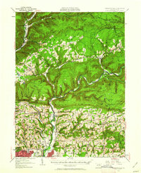
1953 Map of Warrensville
USGS Topo · Published 1962About this map
Lycoming Creek and Loyalsock Creek carve deep valleys through this part of the Allegheny Plateau, defining a landscape of steep ridges and concentrated valley settlements. The mid-century rural character is evident in the cluster of small communities and social institutions, from the Church of the Assumption in the north to the North Eldred Sch near Warrensville. The Pennsylvania railroad line follows the western water gaps through Bodines and Marsh Hill, highlighting the historical importance of these corridors for transport and industry in Lycoming County.
Find a feature on this map
95 named features on this map. Tap any name to fly to it.
Don’t see what you’re looking for? This feature index may not catch every label — zoom into the map to look around manually.
Map Details
Editions of this 1953 Warrensville Map
2 editions found

Other maps of this area

1921 · Williamsport
USGS Topo · 1:48,000

1921 · Trout Run
USGS Topo · 1:62,500

1923 · Trout Run
USGS Topo · 1:62,500

1923 · Williamsport
USGS Topo · 1:62,500

1924 · Milton
USGS Topo · 1:62,500

1925 · Blossburg
USGS Topo · 1:62,500

1927 · Eagles Mere
USGS Topo · 1:48,000

1927 · Blossburg
USGS Topo · 1:62,500

1930 · Warrensville
USGS Topo · 1:62,500

1932 · Eagle Mere
USGS Topo · 1:62,500
Featured Places
- Williamsport, PA
- Faxon, Loyalsock Township
- Hillsgrove Township, PA
- Butternut Grove, Gamble Township
- North Eldred, Eldred Township