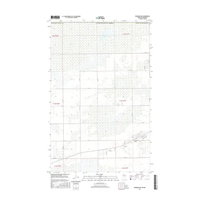
2016 Map of Warroad NW
USGS Topo · Published 2016About this map
Marvin Lake and the subtle rise of Lone Pine Ridge anchor this northern Minnesota landscape in Roseau County. The map reveals a highly structured grid of section lines and township boundaries, including t164n r37w and t163n r37w, typical of the Public Land Survey System's influence on the American Midwest. While much of the terrain is defined by low-lying wetlands and drainage patterns, a pocket of residential development emerges in the southeast corner near the junction of Birchwood Dr and Pine Ridge Rd. This area shows a transition from the vast open tracts of the north towards the more established outskirts of the nearby town center. County routes such as Co Rd 137 and Co Rd 13 provide the primary transit network through this transition between wilder marshland and local settlements.
Find a feature on this map
34 named features on this map. Tap any name to fly to it.
Don’t see what you’re looking for? This feature index may not catch every label — zoom into the map to look around manually.
Map Details
Editions of this 2016 Warroad NW Map
This is the sole edition of this map. No revisions or reprints were ever made.
Other maps of this area

1918 · Goos
USGS Topo · 1:62,500

1918 · Warroad
USGS Topo · 1:62,500

1943 · Goos
USGS Topo · 1:62,500

1943 · Warroad
USGS Topo · 1:62,500

1954 · Roseau
USGS Topo · 1:250,000

1957 · Roseau
USGS Topo · 1:250,000

1958 · Roseau
USGS Topo · 1:250,000

1963 · Kenora
USGS Topo · 1:250,000
1966 · Salol
USGS Topo · 1:24,000
1966 · Salol NE
USGS Topo · 1:24,000