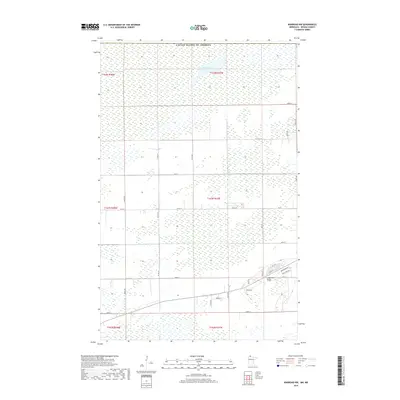
2019 Map of Warroad NW
USGS Topo · Published 2019About this map
Marvin Lake sits in the northern reaches of this Roseau County landscape, positioned just south of the United States of America border. The area is defined by a dense network of sectional roads and extensive wetlands characteristic of this part of northern Minnesota. In the southeastern portion of the map, a small cluster of residential development appears along Lone Pine Ridge, featuring local streets such as Main St, 1st St N, and Birchwood Dr. This small settlement pocket contrasts with the largely uninhabited marshlands and township lines that dominate the surrounding territory. Public transit and regional connectivity are established by routes like Co Rd 13 and Co Rd 137, which grid the landscape into distinct agricultural and natural blocks.
Find a feature on this map
32 named features on this map. Tap any name to fly to it.
Don’t see what you’re looking for? This feature index may not catch every label — zoom into the map to look around manually.
Map Details
Editions of this 2019 Warroad NW Map
This is the sole edition of this map. No revisions or reprints were ever made.
Other maps of this area

1918 · Goos
USGS Topo · 1:62,500

1918 · Warroad
USGS Topo · 1:62,500

1943 · Goos
USGS Topo · 1:62,500

1943 · Warroad
USGS Topo · 1:62,500

1954 · Roseau
USGS Topo · 1:250,000

1957 · Roseau
USGS Topo · 1:250,000

1958 · Roseau
USGS Topo · 1:250,000

1963 · Kenora
USGS Topo · 1:250,000
1966 · Salol
USGS Topo · 1:24,000
1966 · Salol NE
USGS Topo · 1:24,000