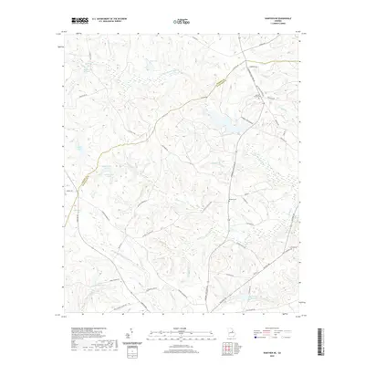
2020 Map of Warthen NE
USGS Topo · Published 2020About this map
The Little Ogeechee River and its numerous tributaries, including Cowpen Creek and Little Cowpen Creek, define this rural section of the Georgia coastal plain. This landscape is characterized by its agricultural and cemetery history, with several family-associated sites such as Burgamy Cem, Mineral Springs Cem, and Cummings Cem serving as landmarks for local genealogists. The influence of local families is further seen in features like Ralph Walker Lake and Burgamy Millpond. Road names such as St Pauls Ch Rd and Wilker School Rd provide clues to the location of early community centers and institutions. Water management and recreational sites are prominent, including McWhorter Pond, Aiken Pond, and Adams Pond North, while Hamburg State Park Rd suggests the proximity of regional recreational land along the Hancock and Washington County line.
Find a feature on this map
64 named features on this map. Tap any name to fly to it.
Don’t see what you’re looking for? This feature index may not catch every label — zoom into the map to look around manually.
Map Details
Editions of this 2020 Warthen NE Map
This is the sole edition of this map. No revisions or reprints were ever made.
Other maps of this area

1953 · Athens
USGS Topo · 1:250,000

1958 · Athens
USGS Topo · 1:250,000

1959 · Athens
USGS Topo · 1:250,000

1960 · Warthen NE
USGS Topo · 1:24,000

1961 · Deepstep
USGS Topo · 1:24,000

1961 · Warthen
USGS Topo · 1:24,000

1961 · Warthen NW
USGS Topo · 1:24,000

1963 · Athens
USGS Topo · 1:250,000

1971 · Beall Springs
USGS Topo · 1:24,000
1972 · Downs
USGS Topo · 1:24,000