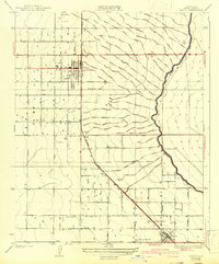
1930 Map of Wasco
USGS Topo · Published 1943About this map
The irrigated plains of the San Joaquin Valley come into sharp focus here, showing the agricultural expansion of central Kern County before the mid-century population boom. At the heart of this landscape is the organized grid of Wasco, which sits alongside the Atchison Topeka and Santa Fe railroad line. The map captures a moment when local infrastructure was heavily dictated by water access and rail transit, visible in the winding path of the Calloway Canal as it cuts across the section lines.
Find a feature on this map
27 named features on this map. Tap any name to fly to it.
Don’t see what you’re looking for? This feature index may not catch every label — zoom into the map to look around manually.
Map Details
Editions of this 1930 Wasco Map
3 editions found
Other maps of this area

1910 · Buena Vista Lake
USGS Topo · 1:125,000

1912 · Buena Vista Lake
USGS Topo · 1:125,000

1927 · McFarland
USGS Topo · 1:31,680

1930 · McFarland
USGS Topo · 1:31,680

1930 · Leonards
USGS Topo · 1:31,680

1930 · Hamlin School
USGS Topo · 1:31,680

1930 · Wasco
USGS Topo · 1:31,680

1930 · Pond
USGS Topo · 1:31,680

1930 · Famoso
USGS Topo · 1:31,680

1930 · Rosedale
USGS Topo · 1:31,680