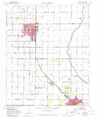
1953 Map of Wasco
USGS Topo · Published 1980About this map
Agricultural development in the San Joaquin Valley defines this mid-century survey, centered on the growing community of Wasco and its neighbor Shafter. The landscape is dominated by a grid of section lines and irrigation infrastructure, including the winding Calloway Canal and numerous reservoirs that support the region's intensive farming. The Atchison Topeka and Santa Fe Railway runs diagonally through the valley, anchoring several industrial and community hubs like North Shafter and the Farm Labor Center. Educational and research institutions are prominent, from local schools like Thomas Jefferson Sch and Richland Sch to the specialized U S Agricultural Experiment Sta. Urban expansion is noted in the southern portion of the map, where residential growth begins to fill the space between established towns and landmarks like the Drive-in Theater and Wasco Airport.
Find a feature on this map
53 named features on this map. Tap any name to fly to it.
Don’t see what you’re looking for? This feature index may not catch every label — zoom into the map to look around manually.
Map Details
Editions of this 1953 Wasco Map
Other maps of this area

1910 · Buena Vista Lake
USGS Topo · 1:125,000

1912 · Buena Vista Lake
USGS Topo · 1:125,000

1927 · McFarland
USGS Topo · 1:31,680

1930 · McFarland
USGS Topo · 1:31,680

1930 · Leonards
USGS Topo · 1:31,680

1930 · Hamlin School
USGS Topo · 1:31,680

1930 · Wasco
USGS Topo · 1:31,680

1930 · Pond
USGS Topo · 1:31,680

1930 · Famoso
USGS Topo · 1:31,680

1930 · Rosedale
USGS Topo · 1:31,680